I had some free time today, being a Sunday, so I did some armchair detective work about this abandoned bridge road, and this is what I found out.
In 1900, the county of Suffolk, at a cost of $13,000 erected a 375 foot steel swing drawbridge from Sag Harbor to North Haven. The access to this bridge was granted in an easement by the LIRR.This bridge lasted until December 28, 1936 when a reinforced concrete bridge opened about 500 feet to the north. This bridge, built at a cost of $200,000 had a 390 foot span with 300 foot causeway approaches. The 1938 bridge lasted until about 2000, when it was reconstructed and widened and serves to this present day.
After some research today, I found the old Rt 114 bridge access road actually became Old Bridge Road. It is listed as such in the 1955 local telephone directory, when I looked under the name Remkus today. The railroad closed in Sag Harbor in 1939 and Jim McMahon, a former mayor who owned a coal yard by the railroad station bought a lot of the property from the LIRR. He in turn, sold some to the Remkus family, no doubt in the late 1940's or so, who opened the fishing station and Seaside Restaurant.
So what does this all mean? It means this little road could be in the spotlight, in what happens in the future at Ferry Road condos. Stay tuned.
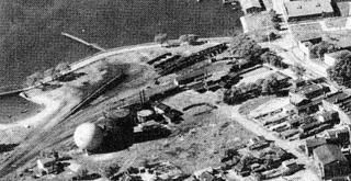
 1935 aerial of the old bridge, and what is known as Old Bridge Road. Railroad yards and gas ball in foreground.
You can see part of the old steel bridge on the left.
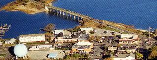
 1999 photo of same area where the newer bridge sits about 500 feet to the north. Notice how the area has been built up in 60 years.


