Sunday, February 22, 2009

The Old Bridge, Continued

Man, I received an e-mail from a local organization today, mainly about Sag Harbor's history. Yesterday I wrote about developers planning a condominium project at the foot of North Haven bridge on the old Diner property. Soooo I joined this local organization's mailing list and poked around their website. Now, I will tell you what I don't like. There is a height issue. Whether it is one building or four, they appear to tower above their neighbors. Second, there is mention of underwater property rights and dredging. Read - MARINA. The Remkus's never had a marina. They had two small wooden docks to dock their fishing boats, and had less than a dozen 16 foot wooden skiffs moored along the shore, which they rented out by the day. Unfortunately, I can see it now; A modern marina like the others in the village. No doubt interfering on the public right of way along the shore front by the bridge.
I had some free time today, being a Sunday, so I did some armchair detective work about this abandoned bridge road, and this is what I found out.
In 1900, the county of Suffolk, at a cost of $13,000 erected a 375 foot steel swing drawbridge from Sag Harbor to North Haven. The access to this bridge was granted in an easement by the LIRR.This bridge lasted until December 28, 1936 when a reinforced concrete bridge opened about 500 feet to the north. This bridge, built at a cost of $200,000 had a 390 foot span with 300 foot causeway approaches. The 1938 bridge lasted until about 2000, when it was reconstructed and widened and serves to this present day.
After some research today, I found the old Rt 114 bridge access road actually became Old Bridge Road. It is listed as such in the 1955 local telephone directory, when I looked under the name Remkus today. The railroad closed in Sag Harbor in 1939 and Jim McMahon, a former mayor who owned a coal yard by the railroad station bought a lot of the property from the LIRR. He in turn, sold some to the Remkus family, no doubt in the late 1940's or so, who opened the fishing station and Seaside Restaurant.
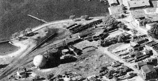
So what does this all mean? It means this little road could be in the spotlight, in what happens in the future at Ferry Road condos. Stay tuned.Photobucket1935 aerial of the old bridge, and what is known as Old Bridge Road. Railroad yards and gas ball in foreground.
You can see part of the old steel bridge on the left.
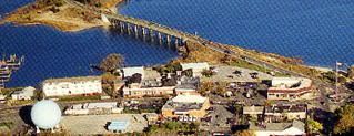
Photobucket1999 photo of same area where the newer bridge sits about 500 feet to the north. Notice how the area has been built up in 60 years.
Saturday, February 21, 2009

The Shore Road Mystery

Man, I was reading a copy of the Sag Harbor Express yesterday, and the Ferry Road Condo's project was again on the front page. Dr. Harry Diner of Noyac owned this property for years, after buying it from the Remkus family in the 1980's. The Remkus's owned the Seaside Restaurant and the Fishing Station at the base of the North Haven bridge. Dr. Diner ran the old restaurant as the Harbor Professional Building for years, until he passed away a few years back. The Diner family sold it to East End Ventures who are hoping to build another big condo complex on the property.
That is a brief history of the project, however a new development has arisen. it concerns a abandoned cement road that runs from the base of the present day bridge to the fishing station. Back it the summer of 1964, my cousin and I would walk along this abandoned road, which led to where the the old wooden bridge to North Haven once stood, a few hundred feet west of the present day bridge. We would get a soda at the machine at the fishing station and walk along the abandoned road back to the foot of the bridge by the flagpole. The road is still there. Look in front of the old Harbor Professional Building next time you come over the bridge and you will see it.
Now there is a dispute on who actually owns this abandoned road. The Long Island Railroad who owned the property in the late 1800's granted an easement to the Village of Sag Harbor, to build this road to the North Haven Bridge. The Save Sag Harbor group had a title search done and it appears the Village of Sag Harbor owns the road and all waterfront property west of the bridge. East End Ventures claims they own at least half the road, and must do so in order to fulfill the necessary setback requirements to build the project as planned.
So where does this stand? I side with the Save Sag Harbor group. They did their homework, studied the history of the site and invested money for title searches. I for one would like to see the Village buy this property and make it into a park. However, I doubt they have that kind of money. They do however as of this date, appear to own the cement road, which is called Shore Road on old postcards, and the associated waterfront property. Who owns Shore Road may be in dispute, but appears to be no longer a mystery. It will not be easy for East End Ventures to claim this road, and will no doubt end in court for several years. And you know something? Tough shit guys!
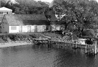
PhotobucketThis is the Sag Harbor side of the old North Haven
bridge where it once terminated by this abandoned
fishing station.(1989 photo)

Friday, February 6, 2009

The Masonic Temple

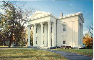
Man, in the 60's, I grew up in a little saltbox 2 bedroom cottage on a 40 by 100 foot piece of property behind the Masonic Temple, A/K/A, Suffolk County Whaling Museum in Sag Harbor. The Masons met on Monday nights, once a month on the second floor of the Masonic Temple. As a matter of fact, as far as I know, they still do. The women's Eastern Star group, met on Thursday nights, once a month. I think this organization ceases to exist in Sag Harbor anymore. The museum, which operated from mid-May to Mid-September was located on the first floor. This building was once the home of Mrs. Russell Sage and built in the 1800's. There was one burglary there in the fall of 1963, where the robbers parked in front of my house one night about 7pm and broke into the museum and stole several rifles. The police later caught the two men. In the 50's and 60's the property was very well kept up. By the 1980's the large rear yard was no longer being mowed and grew knee high. I also noticed the front yard was becoming increasing cluttered with school bells, time capsules, sculptures and other uninteresting things. As decades passed, the building itself fell into disrepair and still is. The building was taken over by new management in the late 1990's and improved. I was inside last summer and although it is ok, I think it could use a complete modernization. The outside has become very rundown. It urgently needs several hundred thousand dollars in funds for repairs. Sad to see this happen. A building like this needs huge sums of money to be maintained. I hope things will work out!
PhotobucketThe museum and grounds in it's glory days, 1960.

Sunday, February 1, 2009

Winter Ice

Man, I was cruising down Long Beach Road the other day and noticed how the ice had built up over the winter. Back in the sixties I would walk out on this ice half a mile toward Jessup's Neck. When your young and stupid, you don't realized that if you fell through, it would be all over in a couple of minutes. But as far as i know, no one ever fell through. I am told that back in the 30's people would drive their cars from Sag Harbor to Cedar Point lighthouse ON the ice. Apparently the winters back then were so cold that the formation of ice would permit this. Today it would be a insane stunt. Getting back to the 60's and ice skating, Trout pond on Noyack Road was never safe due to springs. It is fresh water, but never froze to an extent to permit safe skating. Otter Pond, use to have gates on the bridge which were closed in the winter to keep salt water from the cove from entering the pond. It was used for skating till the early 60's. The metal gates are long gone and so is the ice skating. Round Pond and Fore and After nearby were popular ponds and safe for skating. In North Haven Ryder's Pond has been popular forever. Rounding out the ponds, Long Pond was little used. There are several more ponds in the area and those interested in this great old pastime should view Google satellite maps of the Sag Harbor area as an aid to locating little known ponds that might make an excellent skating spot!
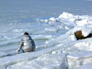
PhotobucketWaiting for the thaw at Long Beach the other day
 
Site Meter